By Shanjid Shane 🕒 Sep 26, 2024
Rare Alert on Hurricane Helene's Flooding Rains and the Risk of a 20-Foot Storm Surge
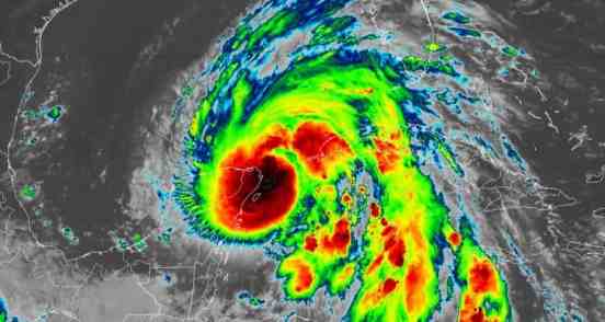
Hurricane Helene is turning out to be a major and potentially catastrophic storm. The National Hurricane Center (NHC) has reported that Helene is likely to strike the Florida coast, notably in the Big Bend area, with storm surges that could hit as high as 20 feet.
Currently categorized as a Category 1 hurricane, it is forecasted to strengthen to a Category 3 or possibly higher before landfall. This intensification is due to the unusually warm waters in the Gulf of Mexico, which are providing the storm with additional energy.
NOAA has issued a special weather statement indicating that “heavy rainfall will commence” in certain areas of the southeastern U.S. “well ahead of” the “unusually large” storm’s anticipated landfall on Florida's northwest coast as a major hurricane on Thursday evening.
Residents must ready themselves for severe and life-threatening flooding from Helene, which may persist even after the storm makes landfall,” stated the National Oceanic and Atmospheric Administration.
Heavy rains linked to the tropical moisture moving northward prior to the storm have already triggered flash flood warnings in parts of Georgia, North Carolina, and Tennessee.
The hurricane, which also poses a threat to portions of Cuba, the Cayman Islands, and the northeastern Yucatan Peninsula with heavy rainfall, has a wind field reaching up to 275 miles from its center, according to NOAA.
The storm is forecast to deliver 6-12 inches of rain across parts of the Southeastern U.S. and into the southern Appalachians, with isolated amounts potentially reaching 18 inches, as reported by the National Hurricane Center.
The impact of a storm surge can be devastating. It can lead to severe coastal flooding, damage to buildings and infrastructure, and significant erosion of beaches and coastal areas. The combination of storm surge and high tide can result in even higher water levels, increasing the flooding.
Residents in the impacted regions are advised to prepare for life-threatening conditions, including severe flooding and destructive winds. Evacuation orders have been issued in multiple counties, making it vital for those in the storm’s path to remain informed and take all essential precautions.
Precautions such as building levees, seawalls, and other barriers can help reduce the impact, but personal preparedness is also essential.
If you are not in an evacuation zone, stay indoors and away from windows. Move to higher ground or the highest level of your home if flooding occurs.
Keep your phone charged and have a backup power source. Use a battery-powered radio to stay updated on the storm’s progress.
Stay Ahead of the News
Before Everyone Else
Major stories break every hour. Join our news community and receive instant alerts, viral headlines, and important updates the moment they happen.